To get to the marina you find the entrance to the Black River off of the Saint Clair River and enter. It is a long way up the Black River to the marina we selected, thru a number of bridges and past a bunch of yacht clubs, boat clubs and other marinas. Bridge Harbor Marina was at the end point of the river that a boat of our size could easily navigate and true to its name it was right next to a very big local bridge that carries I-94 across the river.
We are getting some of our last looks at the Canadian shoreline as a Canadian visitor. Thank you Canada for your hospitality and friendship to us as we traveled your waters. In a couple of hours we will lower your national flag from our "starboard yard arm."
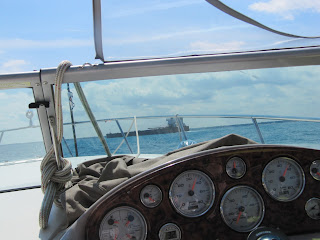
Still on Lake Huron and encountered our first "Salty" A big freighter from across the ocean. You can tell it is a salt water boat from her general shape and features. Among them is the single large orange life boat half way up the "smoke stack" structure at the stern, pointed down at the water. It is arranged this way to simplify deployment in an emergency. You may have to enlarge the photo to see it.
This is a "laker." Different features. The evolution of lake freighters took a path to optimize the designs for these waters. There are some lakers that are near 1000 feet in length. This partially explains why there are many fewer boats on the lakes that in the 50's and 60's when I was familiar with Great Lakes shipping when a 600 footer was regarded as "giant."
Another "laker"
Coming up on the Blue Water Bridge that connects Sarnia with Port Huron. Pretty structure and it is a main artery between Canada and the US. It just so happened that we went under the bridge on the Canadian side. It was an easy choice because that was the side most of the boats going our direction was on. No traffic on that side was going the other way. Turned out that was because the river current going south was intense on that side. We could pick up the uptick in speed on our GPS equipment.
A correction to my statements regarding the intensity of the current, Canadian side vs the American side is in order. Turns out I described it exactly backwards for a variety of reasons. I did note the uptick in speed on the GPS but it appears that the uptick on the American side would have been even better.
My brother Tim who has extensive boating experience on the Great Lakes caught the error. What follows is his text to me. It contains lots of facts.I just read your latest installment of the trip. I think you misstated something about the current in the St. Clair River as the water comes out of Lake Huron and into the river just above the bridge or I misinterpreted what you wrote. The current is much stronger on the American side than it is on the Canadian side. I have gone both ways on a variety of boats with a variety of owners and crews. Everyone is on the Canadian shore going north and the U.S. side of the channel until you can move close to U.S. shore going south.
I made the south bound trip on two boats that were equipped with both GPS and a paddle wheel knotmeter. I don't remember the exact difference in the speed reported on the two instruments but it was surprisingly large. I'm guessing the difference was in the range of 6 to 8 knots, possibly more. It is enough that most sailboats come close to standing still in the current going north on the U.S. side. The current is also slightly stronger in the spring with snow melt and run off than it is in the late summer.
When the Mackinaw sailboats leave the Black River before the race, they basically head straight across the river to the Candian side. They actually crab into the current enough that the current doesn't take them south of the Black River entrance, much as an airplane crabs into wind on a cross wind landing.
The traffic that is stuck in place is US bound. Do you imagine that US customs is checking carefully?
The railroad bridge that carries some tracks across the Black River. We are at the entrance. Railroad bridges are always left in the up position, unlike highway bridges. Since trains are infrequent and very predictable, they are left that way for the convenience of marine traffic. They are only put in the "down" position when a train is about to need to cross.
A highway bridge opened for the river traffic, including us. They open on a schedule. If you miss the opening by just a little bit you will have to wait for the next opening cycle.
An 18 foot Chris Craft run about of the early 1950's vintage. My dad had one exactly like this one in 1955 give or take.
A tiki party barge. We encountered this one a couple of times.
A building along the river with Walcon Siding that was built probably in the mid 1950's. It might be a municipal incinerator.
View from the main building of the Bridge Harbor Marina. We are in there somewhere.
A fellow Floridian.
A dog with his own ramp to the boat. More about him follows.
I guess this handsome dogs really likes boats!
And here are the dog's owners, Bud and Judy. They keep their boat at the slip that just happened to be on the other side of the dock from us. They were a treat to get to know.
Departing our marina in the Zodiac
A classic sail boat under what looks like continuous restoration.
Interesting name for a Bay Liner boat.
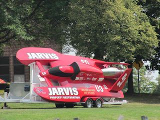
Back on shore. Lots of horsepower here. Look at where the driver sits.
We are once again headed to another port, this time to see my brother, Tim and his wife Kathy aboard their boat kept at Jefferson Beach Marina. Should be fun. The pilot boat ahead of us moved before he became a factor.


